Baruntse Expedition - 31 Days

Trip Facts
Duration 31 Days
Max Altitude 7,129m/23,389ft
Trip Grade Challenging
Best Season Mar-May & Sep-Nov
Meals Breakfast | Lunch | Dinner
Accommodation Teahouse/Tent
Highlights

Baruntse Expedition Highlights

  • Enjoy a scenic and thrilling flight to Tenzing-Hillary Airport
  • Trek through the famous remote Hinku and Barun Valleys, framed by massive peaks like Everest, Lhotse, and Makalu.
  • Peaceful and less crowded trail compared to standard Everest Routes
  • Pass through the protected areas of Makalu Barun National Park, which is home to the rare snow leopard and red panda
  • Follow the historic Southeast Ridge route, first climbed by Colin Todd and Geoff Harrow in 1954.
  • Ascend nearby Mera Peak (6,476m) for optimal acclimatization optional)
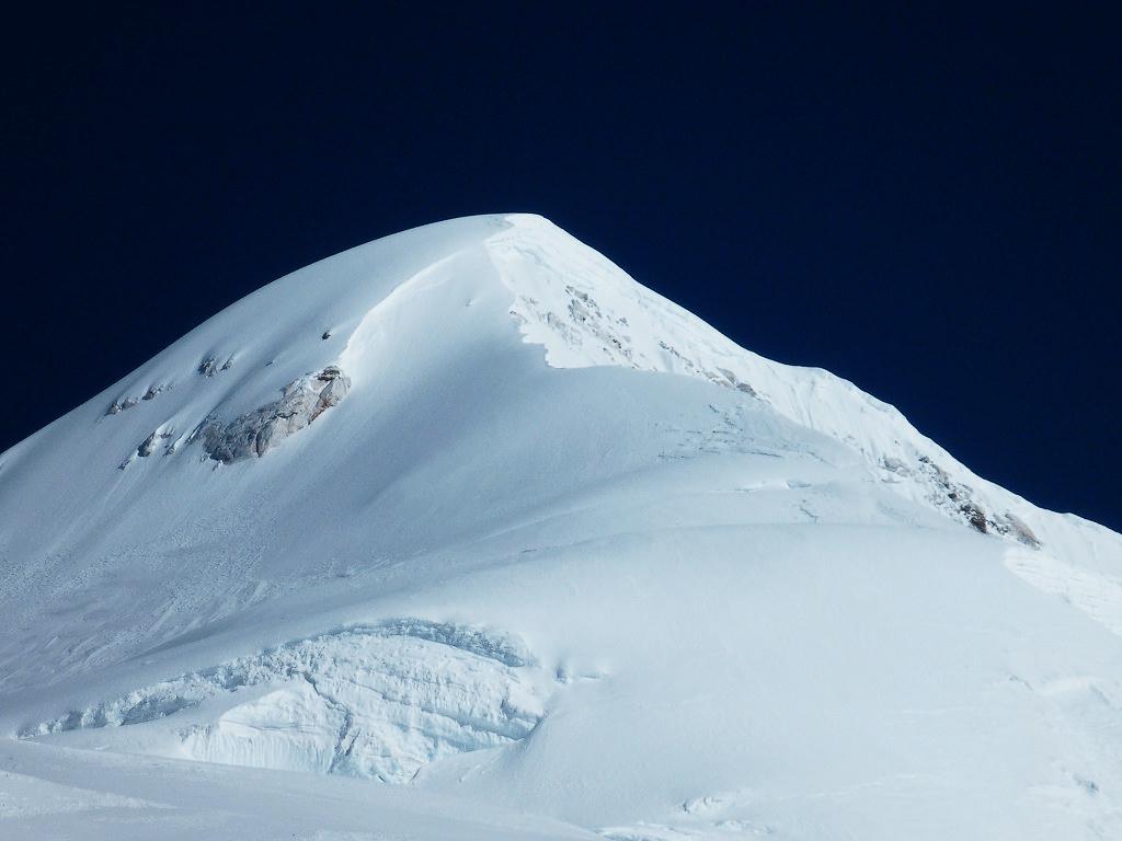
  • Stand at the 7,129 meters (23,389 feet) of Baruntse summit and enjoy the panoramic view of Everest, Makalu, Lhotse, Chamlang, and Ama Dablam.
  • Enjoy spectacular views of Hinku Valley and Glacier, Barun Glacier, and the remote Imja Tse and Makalu-Barun valleys with glacial lakes below.
  • Earn a 7,000m summit certificate and gain valuable high-altitude experience before attempting major peaks such as Everest and Annapurna.
Overview

Baruntse Expedition Overview

This Baruntse Expedition takes you to the summit of Mount Baruntse at an altitude of 7,129 m in the Khumbu Region of Nepal. This semi-technical peak is regulated by Nepal’s Department of Tourism (DoT). Participants must have previous high-altitude and technical climbing experience. 

Your journey of expeditions begins with a scenic 30-minute flight to Lukla Airport. From here, you will trek along a remote route through the Hinku and Barun Valleys. Along the trail, it rewards you with glaciers, glacial lakes, and some of the world’s highest peaks.

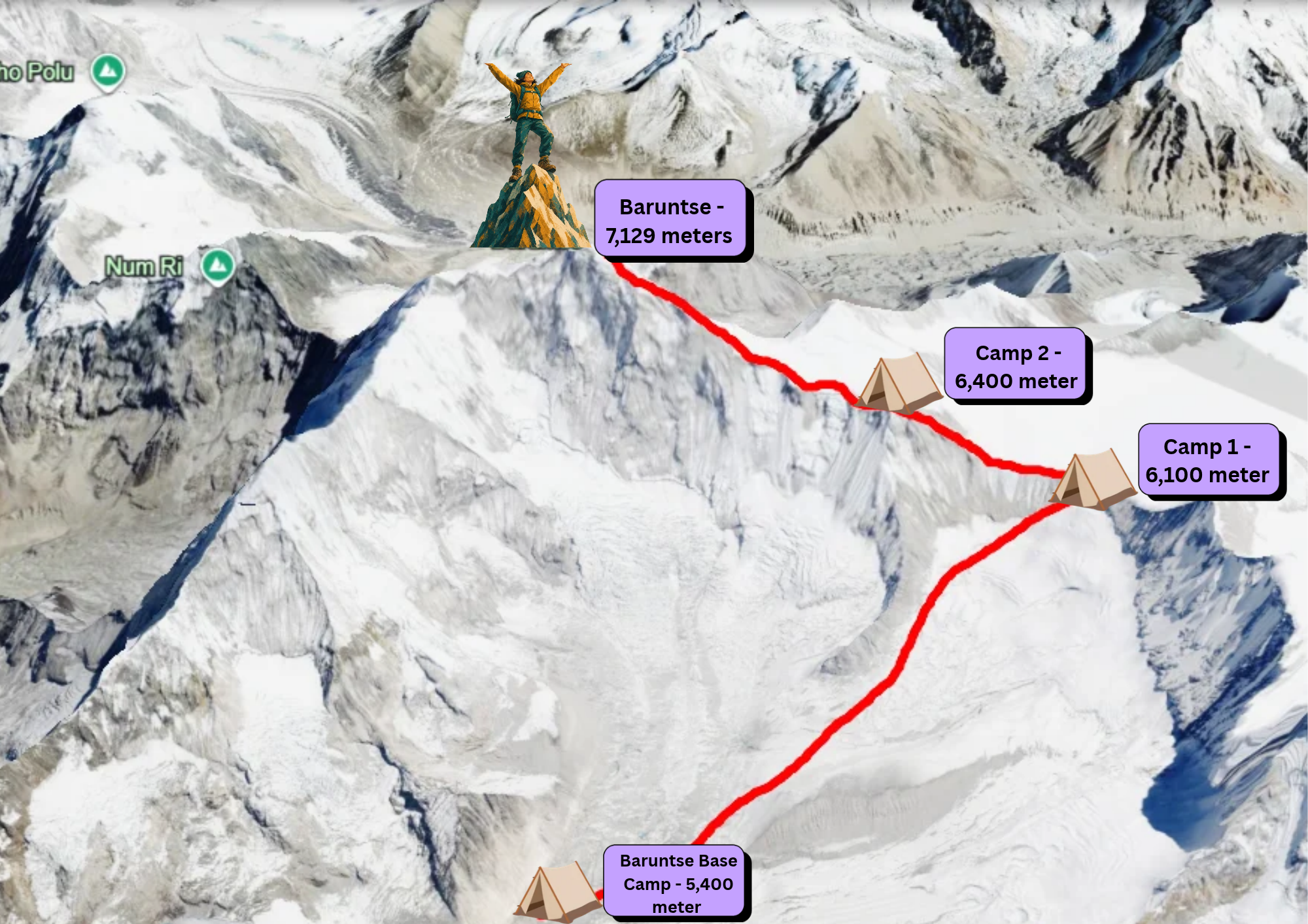
Then, reaching Khare, you will spend a good acclimatization day before heading to Baruntse Base Camp(5,400 meters). Then, from Base Camp, we first complete the acclimatization rotation through High Camp I (approx.6,100m) and Camp 2 (6,400m). Here you will gain valuable information about the route and adjust your body to high altitude.

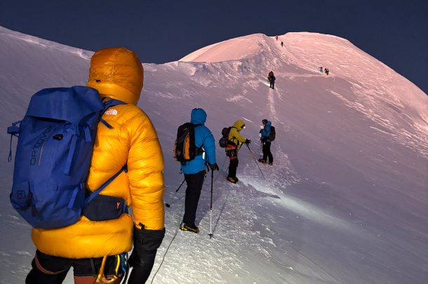
Then, after completion of the rotation, our final ascent of the expedition journey begins. We climb from Base Camp to Camp I and Camp II. Leaving Camp II in total darkness at midnight, around 10:30 PM – 11:00 PM, we start the summit push. We ascend gently through snow and ice, navigating steep sections of the headwall, using fixed ropes where they have been established.

Around 7:00 AM – 9:00 AM, we aim to reach the summit of Baruntse at 7,129 meters. On the clear morning, you can witness the sheer South Face of Lhotse, the massive bulk of Makalu, and Mount Everest piercing the sky. You will spend 15 to 20 minutes taking photos, exploring the awe-inspiring view and then descend to Camp II. Then, after descending further to Base Camp, we trek back to Lukla. From Lukla, we take a scenic flight back to Kathmandu, and we conclude our trip.

Mount Baruntse Climbing Cost For 2027/28

Climbers need to book the package at least 3 to 6 month in advance as Sherpa guide, permits, and expedition logistics need to arrange ahead of time. The climbing cost depends upon group size, preferred services or any additional expedition support. For the exact quotation based on your climbing needs contact our tour operator directly.

Itinerary

Baruntse Expedition Itinerary

Early in the morning, we head to Tribhuvan International Airport(TIA) from our hotel for the flight. We enter the domestic terminal building and, after completing the check-in process,  board our flight. The flight duration will be around 30 minutes. As we leave Kathmandu, you can enjoy aerial views of the Kathmandu Valley, terraced farmland, and surrounding hills. As we approach Lukla Airport, if the weather is clear, distant views of the majestic Himalayan mountains welcome you to the Khumbu region.

Then, after landing in Lukla, we enjoyed a short tea break outside the airport, and then, with our team, we began our trek. Today, our destination is Chutanga, located southwest of Lukla. Leaving the main Everest Base Camp trail, we will enter the Mera region. Along the way, we pass local farms, open scrubland, and rickety wooden bridges before entering a thick, peaceful forest of pine, juniper, and giant rhododendrons. After approximately 3 to 4 hours of walking, we arrive at Chutanga in the afternoon. We check into the teahouse and spend the night here.

⛰ Altitude 3050 meter
🍽 Meals Breakfast, Lunch, and Dinner
🏨 Stay Teahouse

After breakfast in the Chutanga teahouse, we begin our journey by walking through the sparse alpine forest and scrub bushes. Then we steadily climb the Zatrwa La Pass. There will be a quick elevation gain of +1,500 m when we reach the top. From this incredible high mountain pass, you can see panoramic views of the surrounding Himalayan peaks, rugged mountain ridges, and the remote Hinku Valley stretching below.

As we descend from the pass, we walk down a steep path covered in loose rocks. The trail gradually flattens out, leading us through open yak pastures and clusters of rhododendron bushes. We arrive at Thuli Kharka by mid-afternoon, where we will rest and stay overnight at a local lodge.

⛰ Altitude 4100 meter
🍽 Meals Breakfast, Lunch, and Dinner
🏨 Stay Teahouse

After breakfast, we leave Thuli Kharka and walk through the western side of the Hinku Valley. Then, from the ridge, enjoying the view of the valley, we walk steeply downhill. Following the dense alpine forests filled with rhododendron, bamboo, and pine, we stop at Tashing Ongma for rest or lunch. Further walking along the Inkhu/Hinku River path, we pass through Mani walls or small gompas. Then, after arriving at Kothe, we checked into the teahouse and spent the night.

⛰ Altitude 3700 meter
🍽 Meals Breakfast, Lunch, and Dinner
🏨 Stay Teahouse

River). Passing through beautiful rhododendron and pine forests, we enter an alpine landscape. As we gain altitude, the forest thins and the landscape turns into sparse vegetation and rocky hillsides.

In around 2 to 3 hours, we arrive at Gondishung. Here you can see local herders grazing their livestock. Then, a short walk from here, we visit the 200-year-old Lungsumgba Gompa.
After exploring the surroundings of this 200-year-old Gompa, we will reach Gondishung and have lunch. Then, climbing through the river valley, we will arrive at Thangnak early in the afternoon.

We will check in to the teahouse and rest well to acclimatize to the altitude.

⛰ Altitude 4350 meter
🍽 Meals Breakfast, Lunch, and Dinner
🏨 Stay Teahouse

Early in the morning, after breakfast, we will check our Blood Oxygen Saturation (SpO2) and Pulse Rate (PR) using a pulse oximeter. Then we began our journey toward the Khare, which is the Base Camp of Mera Peak. Initially, we followed the glacial valley before crossing the Dig Glacier moraine. After passing Charpate Tal and Dig Kharka, the path becomes steeper and more rugged near the Hinku Nup and Shar Glaciers. Finally, we reach Khare (5,045m), the main staging point for Mera Peak climbing, with spectacular views of Mera Peak.

⛰ Altitude 4350 meter
🍽 Meals Breakfast, Lunch, and Dinner
🏨 Stay Teahouse

Today is the rest day in the Khare. Since we are already around 5,000 metres, it is important to adjust our bodies to the high altitude. Here we take proper rest and monitor our health condition before heading to Bartunse Base Camp. Our Guide will take you on a short hike to practise using climbing gear. Take enough rest, hydrate and enjoy the view.

Note: Climbers who wish to do the Mera Peak climb as an acclimatisation hike can arrange the programme for you. For this, you need to inform us before booking the expedition. An additional 2 to 3 days are required.

⛰ Altitude 4350 meter
🍽 Meals Breakfast, Lunch, and Dinner
🏨 Stay Teahouse

We have breakfast and leave Khare. Today we head into the wild, high land that leads to the Hongu Valley and Baruntse region. The busy trekking area stays behind us. We walk over rough ground and old glacier rubble, with big peaks all around. Trees and plants thin out as we climb. Very few people live along this route. After a few hours, we reach Kongma Dingma at about 4,900 m. Our crew sets up the camp while we rest and adjust to the height. We eat dinner at camp and get ready for the next stage.


⛰ Altitude 4900 meter
🍽 Meals Breakfast, Lunch, and Dinner
🏨 Stay Tent

After breakfast, we walk deeper into the quiet Hongu Valley. The path crosses rocky ground, glacier debris, and wide open valleys. The views get more dramatic as we gain height. Seto Pokhari means "White Lake." It sits in a far corner of the valley, with tall mountains all around. We set up camp, rest, and drink plenty of water.

⛰ Altitude 5035 meter
🍽 Meals Breakfast, Lunch, and Dinner
🏨 Stay Tent

We leave Seto Pokhari and walk toward Baruntse Base Camp. The ground becomes rougher and more icy as we near the Baruntse massif. The peaks look bigger, and the trip now feels like a true expedition. After a few hours, we reach Base Camp at about 5,400 m. Our Sherpa and support team set up the camp. We settle into our tents and start thinking about the climb. From here, we can see Baruntse and the peaks around it.


⛰ Altitude 5400 meter
🍽 Meals Breakfast, Lunch, and Dinner
🏨 Stay Tent

This day is for rest and getting used to the altitude. Our leader checks everyone's health and explains the climbing plan. The Sherpa team gets the ropes, tents, oxygen systems, and other supplies ready. We go over the route and the safety rules for the higher camps. In the afternoon, we rest and prepare our minds and bodies for the climb.

⛰ Altitude 5400 meter
🍽 Meals Breakfast, Lunch, and Dinner
🏨 Stay Tent

Today we practice climbing and glacier skills at Base Camp. Our Sherpa guides teach us how to use crampons and ice axes. We also learn fixed ropes, harnesses, jumaring, rappelling, and glacier travel. We go over emergency steps and how to move on steep snow and ice. The team checks each climber's gear before the first rotation. This covers boots, crampons, harnesses, helmets, ascenders, carabiners, ice axes, and ropes. We spend the rest of the day resting.

⛰ Altitude 5400 meter
🍽 Meals Breakfast, Lunch, and Dinner
🏨 Stay Tent

Our first high climb starts today. We leave early and climb slowly over rock and glacier toward Camp I. The route gets more technical as we go higher. If the route needs it, we use fixed ropes set by the climbing team. After several hours, we reach Camp I at about 6,100 m. We set up camp, eat, drink, and rest. A night here helps our bodies adjust before we go back down.

⛰ Altitude 6100 meter
🍽 Meals Breakfast, Lunch, and Dinner
🏨 Stay Tent

We wake early at Camp I and eat breakfast. Then we make a short climb to gain more height. If weather and route allow, we may climb toward the Camp II area. After some time up high, we go back down to Camp I. From there, we continue to Base Camp. Resting at Base Camp lets our bodies recover and keep the benefit of the climb.

⛰ Altitude 5400 meter
🍽 Meals Breakfast, Lunch, and Dinner
🏨 Stay Tent

This is a full rest day at Base Camp. We focus on water, food, and sleep after our first climb. Our doctor or guide checks our health and oxygen levels. The climbing team studies the weather and the mountain conditions. The Sherpa team keeps carrying gear and preparing the upper camps.

⛰ Altitude 5400 meter
🍽 Meals Breakfast, Lunch, and Dinner
🏨 Stay Tent

Today we get ready for the second climb. The team checks gear, food, oxygen, ropes, and personal items. We hear the latest news on the route and the weather. The leader may change the plan to fit the team and the mountain. We rest for the rest of the day before the climb toward Camp II.

⛰ Altitude 5400 m
🍽 Meals Breakfast, Lunch, and Dinner
🏨 Stay Tent

We start our second climb to the higher camps. The path to Camp I feels easier now. Still, the thin air makes it hard work. We climb steadily and use fixed ropes where needed. We reach Camp I in the afternoon. Then we rest for tomorrow's climb to Camp II.


⛰ Altitude 6100 meter
🍽 Meals Breakfast, Lunch, and Dinner
🏨 Stay Tent

Today we climb from Camp I to Camp II. The route crosses high glacier ground and gets harder. We move with care and use fixed ropes on technical parts. Camp II sits at about 6,400 m. We pitch our tents and settle in for the night. Sleeping at this height is a big help before the summit push.

⛰ Altitude 6400 meter
🍽 Meals Breakfast, Lunch, and Dinner
🏨 Stay Tent

We make a short climb above Camp II if the weather and route allow. The goal is to feel the higher altitude without tiring ourselves out. After that, we go down to Camp I or Base Camp, based on the plan and conditions. Going lower helps us recover before the summit push.

⛰ Altitude 5400 meter
🍽 Meals Breakfast, Lunch, and Dinner
🏨 Stay Tent

We rest at Base Camp and prepare for the summit try. This recovery time is important. Our leader watches the weather and finds a good summit window. The Sherpa team checks the ropes, the upper camps, and the oxygen supply. We also go over the summit plan and emergency steps.

⛰ Altitude 5400 meter
🍽 Meals Breakfast, Lunch, and Dinner
🏨 Stay Tent

This is one more rest and preparation day. We sort our summit gear. That includes boots, crampons, harness, ascender, ice axe, headlamp, down clothing, gloves, and goggles. We get the latest forecast and a final talk from our leader. We eat well, drink plenty of water, and rest as much as we can.

⛰ Altitude 5400 meter
🍽 Meals Breakfast, Lunch, and Dinner
🏨 Stay Tent

The summit push begins today. We leave Base Camp and climb to Camp I. The route is familiar now, so we can keep a steady pace. At Camp I, we get ready for the next step. We spend the evening resting for an early start tomorrow.

⛰ Altitude 6100 m
🍽 Meals Breakfast, Lunch, and Dinner
🏨 Stay Tent

We leave Camp I early and climb to Camp II. The height makes the climb hard, so we go slow and stay in control. At Camp II, we rest and sort our summit gear. Our climbing leader gives a final talk on the route and expected conditions. We try to sleep early.

⛰ Altitude 6400 meter
🍽 Meals Breakfast, Lunch, and Dinner
🏨 Stay Tent

Based on the route and plan, we may move to a higher camp or a good starting point for the summit. The upper part of Baruntse has steep snow and ice, open ledges, and fixed ropes. Our Sherpa team sets and checks the ropes where needed. The place we sleep may change with the weather, route, and how well we have adjusted. We rest as much as possible.

⛰ Altitude 6800 meter
🏨 Stay Tent

This is the hardest and most important day of the expedition. We start very early, often at night, to use the calmer morning weather. The climb has steep snow and ice, fixed ropes, open sections, and narrow ridges. We move slowly and carefully with our Sherpa team. Near the top, the ground becomes more exposed and harder. After the last technical parts, we stand on the summit of Baruntse at 7,129 m. If the weather is clear, we can see Makalu, Everest, Lhotse, and other giants. We stay briefly, then head down the same route. We sleep at a lower camp, depending on our condition and the weather.

⛰ Altitude 7129 meter
🍽 Meals Breakfast, Lunch, and Dinner
🏨 Stay Tent

We go down from the high camps to Baruntse Base Camp. The descent is tiring because we are worn out from the summit push. We take care on the technical parts and fixed ropes. At Base Camp, we rest, eat, and drink. If the team needs another summit try, we may use this day as a spare day.

⛰ Altitude 5400 meter
🍽 Meals Breakfast, Lunch, and Dinner
🏨 Stay Tent

With the climb done, we start our journey back. We pack the gear and leave Base Camp. The trail crosses wild, rough land toward Amphu Lapcha Base Camp. The views stay stunning, with tall peaks all around. After a few hours, we reach the camp area and set up our tents.

⛰ Altitude 5400 meter
🍽 Meals Breakfast, Lunch, and Dinner
🏨 Stay Tent

This is one of the toughest trekking days. We start early and climb to Amphu Lapcha Pass at 5,845 m. The route has steep, technical parts, and we may need fixed ropes. From the top, we enjoy wide views of the peaks. Then we go down toward the Everest region. The trail ends at Chhukung, about 4,730 m. We check into a lodge and take a well-earned rest.

⛰ Altitude 4730 meter
🍽 Meals Breakfast, Lunch, and Dinner
🏨 Stay Teahouse

After breakfast, we leave Chhukung and walk down toward Namche Bazaar. The trail follows the lovely Imja Valley and joins the main Everest route. As we descend, greenery returns and the air feels warmer. We pass mountain villages and Buddhist sites on the way. We reach Namche Bazaar by afternoon or early evening. We check into the lodge, have a hot meal, and relax.

⛰ Altitude 3440 meter
🍽 Meals Breakfast, Lunch, and Dinner
🏨 Stay Teahouse

This is our last trekking day. We leave Namche Bazaar and follow the known trail to Lukla. We walk through rhododendron and pine forests and cross suspension bridges over the Dudh Koshi. The path passes several Sherpa villages in the lower Khumbu. After a few hours, we arrive in Lukla. In the evening, we celebrate our successful Baruntse Expedition with the whole team.

⛰ Altitude 2860 meter
🍽 Meals Breakfast, Lunch, and Dinner
🏨 Stay Teahouse

After breakfast, we go to Lukla Airport for the flight to Kathmandu. The flight takes about 30 minutes. It gives us one last aerial look at the Himalayas. Our representative meets us at the airport and takes us to the hotel. The rest of the day is free for rest, shopping, or exploring the city. In the evening, we share a farewell dinner to celebrate the expedition.

⛰ Altitude 1400 meter
🍽 Meals Breakfast
🏨 Stay Hotel

This is the last day of your Baruntse Expedition in Nepal. Our representative will take you to Tribhuvan International Airport, based on your flight time. You leave Nepal with great memories of Baruntse, the quiet Hongu Valley, the high camps, and the mighty Himalayas.

⛰ Altitude 1400 meter

Build Your Own Adventure!

Collaborate with our specialists to create a unique itinerary.

Things to Know

Notes

How difficult is it to climb Baruntse Peak in Nepal?

Difficulty level: AD+ (Assez Difficile Plus) or level

  • High-Altitude Climb: Mount Baruntse summit takes you to an incredible altitude of 7,129 m, which increases the risk of AMS, HAPE, HACE, hypothermia, and extreme cold.
  • Steep Slopes: Climbers need to use a rope and cross the 45-degree to 50-degree steep snow and ice slopes. The challenging West Col Ice Wall also involves climbing a steep 45° ice wall.
  • Technical Climbing: Baruntse is a semi-technical peak which demands advanced mountaineering skills.
  • Fixed Ropes: Using fixed ropes requires core endurance, proper footwork, balance, and good rope-handling skills
  • Crevassed Terrain: The Camp 1 approach includes extensive crevasse fields, where climbers may weave between cracks or cross aluminum ladders fixed over deep ice crevasses. Proper crevasse crossing technique is required.
  • Exposed Sections: The upper routes feature steep ice slopes, exposed ridges, deep crevasses, and cornices. We need to use the rope most of the time to cross the narrow and exposed sections.
  • Long Summit Day: The summit push lasts for 10 to 12 hours. To complete this round trip, climbers need to have a high level of stamina, courage, determination and physical preparation.
  • Weather: Weather in the mountains is unpredictable sometimes. The sudden shift in weather results in strong winds, extreme cold, low visibility, heavy snowfall and avalanches as well.

Overall: Baruntse is a serious but achievable 7,000-meter expedition for well-prepared climbers with appropriate technical skills, a proper team and acclimatization.

How to prepare for the Baruntse Peak Expedition?

  1. Physical Fitness & Training (5 to 6 Months Prior): There is no room for mistakes in the mountains. Therefore, we need to prepare in advance for the safe and successful ascent. Spend at least 5 to 6 months building endurance, leg strength, core strength, and cardiovascular fitness.
  2. Technical Mountaineering Prerequisites: Gain full experience using climbing gear such as crampons, ice axe, fixed ropes, and ascenders. Technical skills are necessary before joining the expedition. We recommend getting some experience by climbing trekking peaks such as Mera Peak, Lobuche East or Island Peak.
  3. Acclimatization Strategy: Follow the well-planned acclimatization schedule and, if possible, do hypoxic tent training. 
  4. Essential Gear & Equipment: Investing in high-quality climbing gear and clothing is essential. Choose wisely, so it fits and works for you.
  5. Logistics, Permits & Safety: Choose the best season for the expedition, book permits, the right insurance company and prepare a proper budget.

Best Season and Summit Window for Baruntse Peak

For Baruntse Peak, the most favourable conditions for climbing are during the spring (April–May) and the autumn(September–October) season. The best summit windows are selected during these seasons due to stable mountain conditions, clear skies, and better weather.

This season offers lower winds and stable snow and ice conditions. The risk of avalanche is also low compared to other seasons. Also, temperatures are favourable for crossing the glacier, crevasses, open ridge, and steep sections.

Most climbers prefer to climb Baruntse during the autumn and seek spring as an alternative. Monsoon and winter are not recommended because of unfavorable weather, heavy snowfall, and increased climbing risks.

Permits and Requirements for Baruntse Peak Expedition

The Department of Tourism (DoT) issues the climbing permit through your registered expedition agency. You cannot obtain the permit independently. Hiring a qualified climbing guide with the required insurance coverage is also mandatory. To participate in this expedition, you need to have the following permits with you:

  1. Baruntse Mountaineering Royalty Permit
  2. Makalu Barun National Park Entry Permit
  3. Sagarmatha National Park Permit
  4. Khumbu Pasanglhamu Rural Municipality Local Permit

Food and Accommodation on Baruntse Peak Climbing Journey

The availability of food and accommodation depends upon two sections:

Teahouse From Lukla to Khare): Here the teahouse provides a variety of Nepali dishes such as Dalbhat, noodles, momos, and soups. Some Western food, such as pizza, burgers, and spaghetti, is also available depending on the teahouse location and altitude. Accommodation is generally simple. You can expect a cozy room with twin beds and shared toilets. Blankets, pillows, and bedsheets are provided, but due to the cold, we recommend carrying sleeping bags with you. 

Set up tent ( Above Khare): Since there are no teahouses above the Khare, our expedition team will set up the tent for our climbers. There will be a tent for sleeping, a kitchen and a washroom. A dedicated team will cook a simple veg meal for you. While you are in the tent, there will be no facilities for Wi-Fi, charging, or mobile network.

Facilities on Barunste Peak Climbing

Wi-Fi, hot showers, charging facilities, and mobile connectivity are available in most teahouses along the lower sections. However, these facilities become limited or unavailable at higher altitudes. Once you move into tented camps, Wi-Fi, charging facilities, and mobile networks are generally unavailable.

We recommend that climbers bring personal snacks, hygiene items, a power bank, and other essential personal supplies. 

Expert Tips from Sardar (Sherpa)

  1. Master the Pace. Know when to rest and when to walk.
  2. Learn breathing techniques, especially for steep technical sections.
  3. Never skip rotational climbs, no matter how experienced a climber you are.
  4. Consume nutritious, high-calorie meals to maintain energy.
  5. Talk regularly with your Sherpa guide to discuss weather windows, gear checks, and strategy.
  6. Honor local culture by participating in the Pooja ceremony, which is especially done before the summit push.
  7. Stick to the turnaround time during the summit push.
  8. Choose your summit day based on weather, wind, snow, and route conditions - not a fixed date.

Map

Baruntse Expedition Route Map

Altitude Chart

Equipment

Here is the full packing list for the Baruntse Expedition

Bags & Backpacks

Large expedition duffel bag, 50–70L trekking backpack, 20–30L summit/day pack, waterproof backpack cover, dry bags, packing cubes, duffel locks

Clothing – Base & Trekking

Moisture-wicking T-shirts, long-sleeve shirts, thermal base-layer tops, thermal long johns, trekking trousers, soft-shell trousers, fleece jacket, lightweight down jacket, heavy expedition down jacket, waterproof and windproof hardshell jacket, waterproof trousers, lightweight windbreaker, underwear, trekking socks, liner socks, warm wool socks, sun hat, warm beanie, neck gaiter or Buff, balaclava

High-Altitude & Summit Clothing

Expedition down suit, down pants if using a separate system, expedition-weight insulated jacket, expedition mittens, waterproof outer gloves, warm liner gloves, heavy wool or insulated socks, expedition balaclava, warm hat, face mask, high-altitude gaiters

Footwear

Waterproof trekking boots, double or high-altitude mountaineering boots, camp shoes or sandals, crampon-compatible boots, spare laces

Technical Climbing Equipment

12-point mountaineering crampons with anti-balling plates, ice axe with leash, climbing harness, helmet, full-size ascender or Jumar, figure-8 descender or belay device, locking carabiners, non-locking carabiners, climbing slings, accessory cord or Prusik loops, climbing gloves, crampon bag

Trekking & Glacier Travel

Trekking poles, headlamp, backup headlamp, extra batteries, glacier sunglasses, snow goggles, waterproof gaiters, whistle

Sleeping Gear

Four-season expedition sleeping bag, sleeping bag liner, insulated sleeping mat, closed-cell foam pad, inflatable sleeping pad, sleeping pad repair kit, lightweight pillow or pillowcase, earplugs, eye mask

Personal Medical & First Aid

Personal first-aid kit, prescribed medicines, blister treatment, pain relief medicine, antiseptic wipes, bandages, adhesive tape, personal medical supplies, oral rehydration salts, electrolyte tablets, basic altitude medication as advised by your doctor, sunscreen SPF 50+, lip balm with SPF

Hydration & Nutrition

Insulated water bottles, water bottles, thermos flask, hydration bladder if suitable, water purification tablets or filter, electrolyte powder, energy bars, chocolate, nuts, dried fruits, glucose sweets, personal high-calorie snacks

Toiletries & Hygiene

Toothbrush, toothpaste, biodegradable soap, hand sanitizer, wet wipes, toilet paper, quick-dry towel, lip balm, sunscreen, deodorant, personal hygiene products, small nail clipper, biodegradable bags for waste

Electronics & Power

Mobile phone, power bank, charging cables, universal travel adapter, spare batteries, headlamp batteries, GPS or altimeter watch, camera, spare memory cards, camera batteries, protective electronics pouch

Navigation & Communication

GPS device or GPS watch, compass, emergency whistle, personal satellite communicator if desired, waterproof document pouch

Travel & Documents

Passport, copies of passport, passport-size photographs, travel insurance documents, emergency contact details, flight documents, permit copies, vaccination or medical documents if required, waterproof document folder

Miscellaneous & Personal Items

Sunglasses case, small repair kit, duct tape, multi-tool, zip-lock bags, waterproof bags, small towel, notebook and pen, reading material or e-reader, camera accessories, small personal snacks, reusable waste bags

FAQs

FAQs of Baruntse Expedition

  • Where is Mount Barunste located in Nepal?

    Mount Barunste (7,129 meters / 23,389 feet) is located in the Khumbu region of eastern Nepal, inside the Sagarmatha and Makalu Barun National Park. It is surrounded by the Imja Tse, Cho Polu, Hongku Chuli and the Himalayan Glacier.
  • Can climbers participate without previous climbing experience?

    No, climbers must have high-altitude trekking experience and basic mountaineering skills to participate in this expedition.
  • What happens if the weather conditions don't improve for several days?

    Your climbing leader will assess the weather, route conditions, and safety before deciding the next step. If conditions remain unsafe, the team may wait for a suitable summit window, adjust the climbing schedule, or retreat to a safer camp. Safety always comes first.
  • Do I need to carry an oxygen bottle for this expedition?

    No, supplemental bottled oxygen is generally not required for the Baruntse Expedition. However, for additional safety, climbers may carry a portable oxygen bottle if desired. As a backup for emergencies, emergency oxygen cylinders, masks, and regulators are kept at Base Camp.
  • Do I need to carry my passport all the time during the expedition?

    As per the new rules, foreign citizens no longer need to carry the physical passport all the time with them. They can keep the digital copy with them.
  • Is this Barunse peak technically challenging?

    Yes, it is technically challenging, but with enough planning and preparation, many climbers have successfully conquered it.
  • Can I climb Mount Everest after I successfully summit Barunste?

    To get the Mount Everest permit, you need to submit your 7,000 m+ peak in Nepal. Since Barunse is 7,129 meters, it meets the proposed requirement for climbing Everest. However, you still need to prepare well enough before attempting the world's highest peak.
Traveler Reviews

What Our Customers Say

Real experiences shared by trekkers and travelers who joined our trips.

Oliver Brown, Australia

I highly recommend High Route Adventure for the Baruntse Expedition in Nepal. From the beginning, the team was professional, friendly, and well organized. They clearly explained the expedition plan, climbing schedule, acclimatization process, and necessary preparations for this challenging 7,129-meter Himalayan peak.

The Baruntse climbing experience was demanding but incredibly rewarding. Our Sherpa team was experienced and supportive throughout the expedition. They provided valuable guidance on the technical sections, high-altitude conditions, and summit preparation. I always felt that safety was treated as the highest priority.

The expedition logistics were also handled very smoothly. High Route Adventure took care of the necessary permits, camps, transportation, and climbing arrangements, allowing us to focus on acclimatization and preparing for the summit. The mountain scenery around Baruntse Base Camp and the surrounding Himalayas was absolutely spectacular.

Overall, my Baruntse Expedition with High Route Adventure was an unforgettable Nepal mountaineering experience. Their experienced Sherpa team, professional service, and strong attention to safety made a difficult high-altitude climb much more manageable. I would gladly choose High Route Adventure again for another Himalayan expedition in Nepal.

Marco Rossi, Italy

An amazing Himalayan adventure from start to finish. High Route Adventure provided excellent Sherpa support and carefully managed the expedition logistics. The mountain views were incredible, and the summit experience was unforgettable.

Daniel Martin, France

Baruntse was one of the most challenging climbs I have completed, but the team made the expedition smooth and well organized. The logistics, camps, permits, and climbing support were handled professionally. Highly recommended.

Lukas Schneider, Germany

I had a fantastic experience climbing Baruntse with High Route Adventure. The Sherpa team was strong, friendly, and very professional. Their support at high altitude gave us confidence during the difficult sections of the climb.

Michael Anderson, United States

High Route Adventure provided excellent support throughout our Baruntse climb. The guides were knowledgeable about the mountain and always prioritized safety. The expedition was challenging but extremely rewarding.

James Wilson, United Kingdom

Our Baruntse Expedition with High Route Adventure was an unforgettable experience. The Sherpa team was professional, experienced, and supportive throughout the climb. Everything was well organized, from base camp logistics to the summit push.

Related Packages

You may like these packages too !
Lobuche Peak Climbing - 17 Days | Cost | Itinerary
Climbing, Trekking in Nepal

Lobuche Peak Climbing

Mera & Island Peak climbing via Amphu Labtsa Pass
Climbing

Mera & Island Peak Climbing via Amphu Labtsa Pass

Chhukung Ri
Climbing

Chhukung Ri Climbing

Putha Hiunchuli Expedition
Climbing

Putha Hiunchuli Expedition

Mera Peak Climbing 13-Day Itinerary
Climbing

Short Mera Peak Climbing 

Yala Peak Climbing
Climbing

Yala Peak Climbing

Chat via WhatsApp +977 9851058664

Our Partners

We are associated with

High Route Adventure TripAvisor Award 2025 High Route Adventure TripAvisor Award 2025